
Drones are transforming how we inspect bridges, power lines, pipelines, and critical infrastructure, making inspections safer, faster, and more cost-effective than ever before.
🚁 The Dawn of Aerial Infrastructure Assessment
Infrastructure inspection has traditionally been a dangerous, time-consuming, and expensive endeavor. Workers have historically climbed towering structures, suspended themselves from bridges, or used expensive helicopters to assess the condition of critical assets. The emergence of drone technology has fundamentally disrupted this paradigm, offering unprecedented access to hard-to-reach areas while dramatically reducing risk to human life.
The global infrastructure inspection market is experiencing rapid transformation. According to industry analysts, the commercial drone market for infrastructure inspection is projected to reach billions of dollars within the next decade. This explosive growth reflects not just technological advancement, but a fundamental shift in how organizations approach asset management and maintenance.
Modern drones equipped with high-resolution cameras, thermal sensors, and LiDAR technology can capture detailed data that would have been impossible or prohibitively expensive to obtain just a decade ago. These unmanned aerial vehicles (UAVs) are reshaping entire industries, from energy and transportation to telecommunications and construction.
Breaking Down the Technology Revolution
Today’s inspection drones are sophisticated flying platforms packed with cutting-edge technology. Advanced stabilization systems allow them to hover precisely in challenging wind conditions, while obstacle avoidance sensors prevent collisions with structures during close-proximity inspections. The onboard sensors represent perhaps the most significant advancement in inspection capabilities.
High-Resolution Imaging Systems
Modern drones carry cameras capable of capturing images with resolutions exceeding 20 megapixels. These high-definition visuals enable inspectors to identify cracks, corrosion, and structural defects as small as a few millimeters from safe distances. Zoom capabilities allow operators to examine specific areas of concern without requiring the drone to approach dangerously close to structures.
Multi-spectral and hyperspectral cameras extend inspection capabilities beyond visible light. These sensors can detect moisture intrusion, vegetation encroachment, and material degradation that might be invisible to the naked eye. This expanded sensory range provides maintenance teams with actionable intelligence about potential problems before they become critical failures.
Thermal Imaging and Heat Detection
Thermal cameras mounted on drones have revolutionized electrical infrastructure inspection. These sensors detect heat signatures that indicate loose connections, overloaded circuits, or failing components in power transmission systems. Solar farm operators use thermal imaging to identify defective photovoltaic panels across massive installations in a fraction of the time traditional methods required.
Building envelope inspections benefit enormously from thermal imaging. Drones can quickly scan entire structures to identify insulation gaps, air leakage, and moisture problems that compromise energy efficiency and structural integrity. This capability has proven particularly valuable for large commercial facilities and residential developments.
LiDAR and 3D Mapping Capabilities
Light Detection and Ranging (LiDAR) technology enables drones to create precise three-dimensional models of infrastructure. These detailed point clouds provide millimeter-accurate measurements and can detect subtle deformations or settlement issues that might indicate structural problems. Transportation departments use LiDAR-equipped drones to assess bridge deflection and monitor structural health over time.
The 3D models generated by drone surveys serve multiple purposes beyond immediate inspection. Engineering teams use them for retrofit planning, maintenance scheduling, and structural analysis. These digital twins of physical assets become valuable repositories of information that support decision-making throughout the asset lifecycle.
Industries Experiencing Dramatic Transformation
Energy Sector: Power Generation and Distribution
The energy industry has emerged as one of the earliest and most enthusiastic adopters of drone inspection technology. Electric utilities face the enormous challenge of maintaining thousands of miles of transmission lines, often traversing difficult terrain. Traditional helicopter inspections were expensive and dangerous, while ground-based visual inspections were slow and limited in scope.
Drones have transformed this equation entirely. Inspection crews can now survey power lines at a fraction of the cost of helicopter operations, while capturing far more detailed imagery. Operators can identify vegetation encroachment, damaged insulators, corroded hardware, and conductor issues before they cause outages. The improved inspection frequency made possible by drones translates directly into enhanced grid reliability.
Wind energy facilities benefit tremendously from drone inspections. Wind turbine blades operate in harsh conditions and require regular assessment for cracks, erosion, and delamination. Drones equipped with high-resolution cameras can inspect blades while turbines remain operational, eliminating the need for costly shutdowns and rope access technicians.
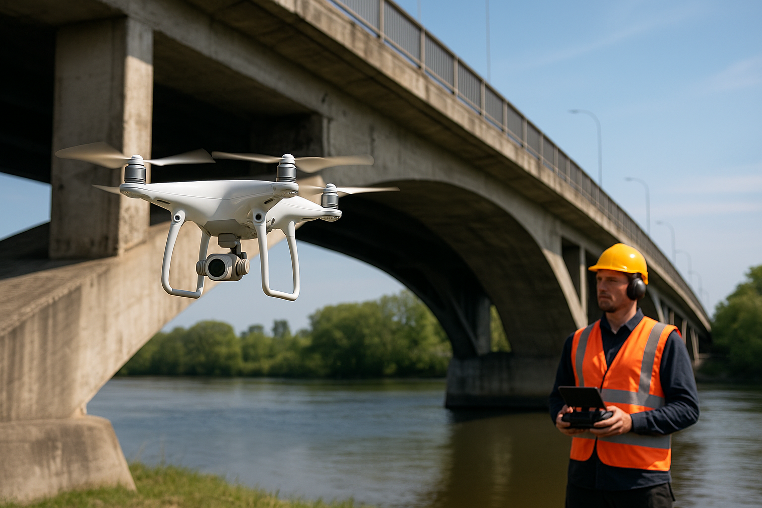
Transportation Infrastructure: Bridges and Roads
Transportation departments struggle with aging infrastructure and limited inspection budgets. Bridges, in particular, present significant inspection challenges. Traditional methods often require lane closures, traffic disruption, and specialized equipment like bucket trucks or snooper trucks that cost thousands of dollars per day to operate.
Drone inspections minimize traffic disruption while providing superior documentation of structural conditions. Inspectors can examine bridge decks, supports, bearings, and expansion joints from multiple angles without the need for expensive access equipment. The comprehensive imagery captured during drone surveys provides permanent documentation that supports engineering analysis and maintenance planning.
Railway operators use drones to inspect tracks, bridges, tunnels, and overhead catenary systems. These inspections can be conducted during maintenance windows without putting personnel at risk from passing trains. The efficiency gains enable more frequent inspections and earlier detection of potential safety issues.
Oil and Gas: Pipelines and Facilities
The oil and gas industry operates extensive networks of pipelines, processing facilities, and storage infrastructure across remote and challenging environments. Regular inspection is critical for safety, environmental protection, and operational efficiency. Drones equipped with multiple sensor types can detect pipeline leaks, corrosion, right-of-way encroachment, and structural issues across vast areas.
Offshore platforms present particularly difficult inspection challenges. Drones can examine flare stacks, processing equipment, and structural components without requiring scaffolding or rope access technicians. This capability not only reduces costs but eliminates exposure to dangerous working conditions in hazardous environments.
Tank farms and storage facilities benefit from drone inspection capabilities as well. Thermal imaging can detect level variations, leak points, and insulation problems across large installations. Visual inspections identify corrosion, coating failures, and structural issues that might compromise containment integrity.
The Safety Imperative: Protecting Human Life
Perhaps the most compelling argument for drone-based infrastructure inspection is the dramatic improvement in worker safety. Industrial accidents during infrastructure inspection have historically resulted in serious injuries and fatalities. Workers fall from heights, encounter electrocution hazards, or suffer injuries from equipment failures. Each inspection conducted by drone instead of human climbers represents a significant reduction in risk exposure.
Confined space entry represents another major safety hazard that drones can mitigate. Small drones can enter tanks, vessels, and other confined spaces to conduct visual inspections without exposing workers to oxygen-deficient atmospheres, toxic gases, or other life-threatening conditions. This capability has proven particularly valuable in the chemical processing and water treatment industries.
The safety benefits extend beyond the inspection teams themselves. Reduced need for lane closures and traffic control minimizes risk to the traveling public. Eliminating scaffolding and access equipment removes potential hazards to workers in surrounding areas. The cumulative safety improvement across all stakeholders represents a fundamental shift in risk management.
Economic Advantages Driving Rapid Adoption
While safety considerations provide powerful motivation for drone adoption, the economic benefits are equally compelling. Traditional infrastructure inspection methods are expensive, requiring specialized personnel, equipment, and often significant operational disruptions. Drones deliver dramatic cost reductions across multiple dimensions.
Direct cost savings come from eliminated or reduced need for expensive equipment rentals, extensive traffic control, and large inspection crews. A two-person drone team can often accomplish what previously required a dozen workers and significant logistical support. The speed of drone inspections means infrastructure can return to service faster, reducing lost productivity and revenue.
Improved inspection frequency enabled by lower costs translates into better asset management. Organizations can shift from reactive maintenance to predictive maintenance strategies, addressing problems before they result in costly failures or unplanned outages. This proactive approach optimizes maintenance spending while extending asset lifecycles.
The comprehensive documentation provided by drone inspections creates additional value. High-resolution imagery and 3D models support more accurate condition assessments and better-informed decision-making. This improved information quality reduces the risk of premature replacements or catastrophic failures due to overlooked defects.
Navigating the Regulatory Landscape ✈️
The rapid proliferation of commercial drone operations has prompted regulatory agencies worldwide to develop frameworks governing their use. In the United States, the Federal Aviation Administration (FAA) regulates commercial drone operations through Part 107 of the Federal Aviation Regulations. This certification process requires operators to pass an aeronautical knowledge test and follow specific operational limitations.
Key regulatory restrictions include maintaining visual line of sight with the aircraft, operating only during daylight hours or civil twilight with appropriate lighting, and respecting altitude limitations. These rules ensure safe integration of drones into the national airspace while minimizing risk to manned aircraft and people on the ground.
Infrastructure inspection operations frequently require waivers from standard regulations. Inspecting tall structures may necessitate altitude waivers, while complex industrial environments might require beyond visual line of sight (BVLOS) authorizations. The waiver process, though sometimes time-consuming, has become more streamlined as regulatory agencies gain experience with commercial drone operations.
International regulatory environments vary considerably. European Union regulations, Canadian Transport requirements, and regulations in other jurisdictions each present unique compliance challenges. Organizations operating across multiple countries must navigate this complex regulatory patchwork to maintain compliant operations.
Overcoming Implementation Challenges
Despite the clear advantages, organizations face several challenges when implementing drone inspection programs. Initial capital investment in equipment represents a significant barrier for some organizations. Professional-grade inspection drones with advanced sensors can cost tens of thousands of dollars, and organizations typically need multiple aircraft to ensure operational continuity.
Workforce development presents another challenge. Effective drone inspection requires personnel who understand both aviation operations and the specific technical requirements of infrastructure assessment. Organizations must invest in training programs that develop these hybrid skill sets, combining traditional inspection expertise with drone piloting capabilities and data analysis skills.
Data Management and Analysis
Drone inspections generate massive quantities of data. A single bridge inspection might produce thousands of high-resolution images and gigabytes of sensor data. Managing, organizing, and analyzing this information requires robust data management systems and processes. Many organizations struggle with the transition from traditional paper-based inspection records to comprehensive digital asset management platforms.
Artificial intelligence and machine learning technologies are emerging as solutions to the data analysis challenge. Automated defect detection algorithms can review thousands of images, flagging potential problems for human review. These AI-assisted workflows dramatically improve inspection efficiency while reducing the risk of overlooked defects due to inspector fatigue or information overload.
The Future of Infrastructure Inspection Technology
Drone technology continues to evolve rapidly, with ongoing developments promising even greater capabilities. Improved battery technology extends flight times, enabling inspection of larger areas on a single flight. Enhanced autonomy features allow drones to conduct complex inspections with minimal human intervention, following pre-programmed flight paths while automatically adjusting for environmental conditions.
Beyond visual line of sight (BVLOS) operations represent the next frontier in commercial drone deployment. Regulatory approval for BVLOS flights would enable inspection of pipelines, power lines, and other linear infrastructure across vast distances without requiring teams to reposition constantly. Several pilot programs are demonstrating the viability of these operations with appropriate detect-and-avoid technology.
Integration with other emerging technologies will further enhance drone inspection capabilities. Edge computing enables real-time data processing onboard the aircraft, providing immediate feedback to operators about detected anomalies. Digital twin platforms integrate drone-collected data into comprehensive virtual models that support predictive maintenance and lifecycle management strategies.
Transforming Asset Management Strategies
The availability of comprehensive, high-quality inspection data is fundamentally changing how organizations manage infrastructure assets. Traditional time-based maintenance schedules are giving way to condition-based approaches that prioritize interventions based on actual asset condition rather than arbitrary timeframes. This transition optimizes maintenance spending while improving asset reliability and safety.
Predictive analytics leveraging historical inspection data enable organizations to forecast when specific components are likely to require intervention. Machine learning algorithms identify patterns in deterioration rates, helping maintenance planners optimize intervention timing and resource allocation. This data-driven approach represents a fundamental shift from reactive to proactive asset management.
The transparency provided by comprehensive drone inspection programs improves stakeholder communication. Detailed visual documentation helps engineers explain maintenance needs to non-technical decision-makers and budget authorities. Regulators and oversight agencies benefit from more thorough and frequent inspection reporting, improving their confidence in asset safety and reliability.
Embracing the Aerial Revolution 🎯
The transformation of infrastructure inspection through drone technology represents more than just the adoption of new tools. It reflects a fundamental reimagining of how we monitor, maintain, and manage the critical systems that support modern society. Organizations that embrace this technology gain competitive advantages through improved safety, reduced costs, and enhanced asset management capabilities.
Success with drone inspection programs requires more than simply purchasing equipment. Organizations must develop comprehensive strategies addressing regulatory compliance, workforce development, data management, and integration with existing business processes. Those that invest thoughtfully in these foundational elements position themselves to realize the full potential of this transformative technology.
The continuing evolution of drone capabilities, regulatory frameworks, and supporting technologies promises even greater capabilities in the years ahead. As autonomous operations become routine, artificial intelligence enhances data analysis, and integration with broader digital transformation initiatives deepens, drones will become ever more central to infrastructure management strategies. Organizations beginning their drone inspection journey today are laying the groundwork for decades of improved asset performance and safety outcomes.